To see a full map of the Mill Cities Relay course, click here.
Below are the routes of each leg of the course. There are also alternate driving routes at the bottom.
| Distance | Description | |
|---|---|---|
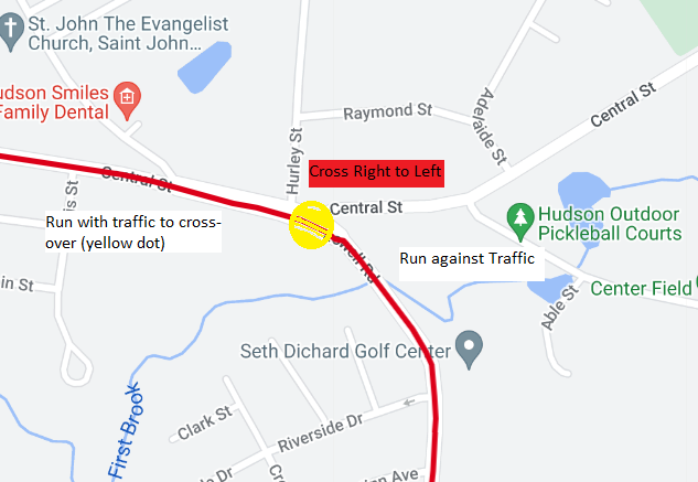
| 1 | 5.65 miles | This leg starts at the Eagles Wing Function Hall, 10 Spruce Street in Nashua, NH. Runners go right onto Temple St. then turn left on E. Hollis St. crossing to the right side of the road (facing Hudson). The leg continues on the right side of the bridge straight across the bridge and into Hudson, NH. After crossing the bridge take the first right onto Central St. Runners stay to the right until the start of Rte. 3A (Lowell Rd.) where they cross to the left (against traffic).
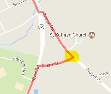
(Runners crossing before the designated point risk penalty/disqualification. This is a safety issue and applies to all crossovers; please follow the rules.) Continue down on the left side of the road until the intersections of Lowell, Dracut and River Roads. Runners will bear left onto Dracut Road. Slightly up the road, your second crossover will be a right down Stuart Street. (map)
Runners will take a left at the end of Stuart Street and continue on River Road until Exchange Zone 1. PLEASE NOTE: If you plan on following the progress of the race during leg 1, please leave Eagles Wing Hall by 7:45 am. This will help us prevent a traffic jam crossing the river.
|
| 2 | 4.75 miles | This leg starts behind the Sears Warehouse building located at the corner of Rte. 3A (River Rd) and Pine Rd in Hudson, NH (across from the entrance of BAE System located at 65 River Road). Do not park on Rte. 3A. there is ample parking adjacent to the building. Continue south on 3A into Tyngsboro (Frost Rd) until you reach Lawndale Rd, go left here. Follow Lawndale Rd to Colburn Rd. Follow Colburn Ave to a three way stop, go straight across onto Sherburne Ave. Continue straight on Sherburne Ave until you reach the rear entrance of the Greater Lowell Technical High School. Exchange Zone 2 will be before the turn-under around the school. Spectators and support personnel please park in in one of the adjacent parking lots.
|
| 3 | 2.5 miles | From Exchange Zone 2 your will exit the Greater Lowell Technical High School from the front entrance and left onto Rte 113. Parking on Rte. 113 at exchange 2 is NOT ALLOWED. There is plenty of parking in the Greater Lowell Technical High School parking lot. Leg 3 goes straight on Rte. 113, into Lowell. Just before reaching the Rourke Bridge (large metal bridge) you will be directed onto the bike path paralleling the Merrimack River.
|
| 4 | 9.8 miles | The exchange point for this leg is located at the Bellegarde Boathouse directly across from the Dunkin Donuts on Rte. 113. YOU CAN park along Rte. 113 at exchange 3 at the Bellegarde Boat House. There is ample parking in the lot adjacent to the building. This leg proceeds straight on the bike path that runs parallel to the river (snow permitting) until you reach the Sampus Pavillion (large metal white structure). At this point you will merge back onto Rte. 113 and continue straight past the O’Donnell and UMass Lowell Bridges. Please be aware of the traffic at these two busy intersections. (NOTE: Between these two bridges Rte. 113 merges with Rte. 110. You will be going onto Rte. 110. If you remember to keep the Merrimack River to your immediate right, you will be on course.) About 1/2 mile after passing UMass Lowell’s North Campus, you will again be directed onto a bike path that parallels the Merrimack River (snow permitting). Continue straight on the bike path until the end where you will merge back onto Rte. 110. Be very careful here since this is a dangerous curve (aka Deadman’s curve). Continue straight on Rte. 110 into Dracut then Methuen.
New: The exchange point is located on the right side of the street at the New Balance Store parking lot, 596 Lowell St., Methuen, MA.
You cannot park on Rte. 110. Spectators and support personnel, please park in adjacent parking lots or side streets.
|
| 5 | 3.9 miles | 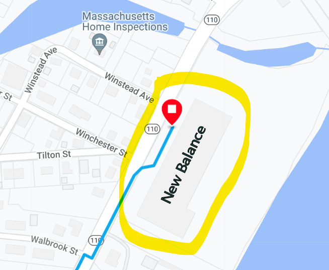
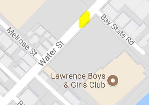
From Exchange Zone 4 you will exit the New Balance parking lot and continue on Rt. 110. Follow Rt. 110 and then bear right after the Dunkin Donuts onto Riverside Drive; run with the flow of traffic (until the designated crossover point). Riverside Drive becomes Water Street when you enter Lawrence. You will be running parallel to the Merrimack River. Continue straight on Water Street until the crossover near the Boys & Girls Club; it will bring you to the left-side of the road. (Runners crossing before the crossover point risk penalty/disqualification. This is a safety issue and applies to all crossovers; please follow the rules.)
Runners will take a left at Rt 28 (Broadway St.), then a right onto Methuen St. Continue on Methuen Street for about a quarter mile. The finish will be located just before the end of the street.
|
ALTERNATIVE DRIVING ROUTES: Here are the links to the bypass driving directions using Google maps.